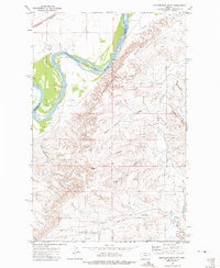
1972 Map of Mortarstone Bluff
USGS Topo · Published 1975About this map
The Missouri River carves a dramatic path through the northern reach of this quadrangle, defining the boundary between Roosevelt and Richland Counties. To the north of the river, the landscape includes a portion of the Fort Peck Indian Reservation and the small community of Riverside, anchored by the Riverside Ch. The southern bank is dominated by the intricate topography of Mortarstone Bluff, where deep drainage patterns such as Eagle Coulee and Simons Coulee create a highly dissected terrain.
Find a feature on this map
24 named features on this map. Tap any name to fly to it.
Don’t see what you’re looking for? This feature index may not catch every label — zoom into the map to look around manually.
Map Details
Editions of this 1972 Mortarstone Bluff Map
2 editions found
Other maps of this area

1909 · Glendive
USGS Topo · 1:250,000

1912 · Poplar
USGS Topo · 1:62,500

1914 · Brockton
USGS Topo · 1:62,500

1950 · Calais
USGS Topo · 1:24,000

1954 · Glendive
USGS Topo · 1:250,000

1954 · Wolf Point
USGS Topo · 1:250,000

1957 · Glendive
USGS Topo · 1:250,000

1958 · Wolf Point
USGS Topo · 1:250,000

1958 · Glendive
USGS Topo · 1:250,000

1972 · Poplar NE
USGS Topo · 1:24,000