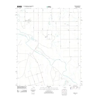
2012 Map of Elmer
USGS Topo · Published 2012About this map
Elmer sits at the northern edge of this survey, where the street grid of Main St, Neville Ave, and numbered streets like 4th St and 5th St meet the regional grid road system. The landscape is defined by the convergence of major waterways, specifically where the Salt Fork Red River joins the larger Red River, which winds prominently across the southern half of the quadrangle. This 2012 map illustrates a rural area centered on small crossroads communities and agricultural infrastructure. To the east, the settlement of Hess is anchored by Hess Cem and a network of rural routes including E1760 Rd and N2080 Rd. Further south, the terrain becomes more varied around Red Hollow, reflecting the drainage patterns and historical geography near the Texas-Oklahoma border.
Find a feature on this map
35 named features on this map. Tap any name to fly to it.
Don’t see what you’re looking for? This feature index may not catch every label — zoom into the map to look around manually.
Map Details
Editions of this 2012 Elmer Map
This is the sole edition of this map. No revisions or reprints were ever made.
Other maps of this area

1955 · Lawton
USGS Topo · 1:250,000

1958 · Frederick
USGS Topo · 1:62,500

1958 · Elmer
USGS Topo · 1:62,500

1963 · Altus SE
USGS Topo · 1:24,000

1964 · Tipton
USGS Topo · 1:24,000

1964 · Olustee
USGS Topo · 1:24,000

1975 · Elmore City NE
USGS Topo · 1:24,000

1975 · Frederick SW
USGS Topo · 1:24,000

1975 · Frederick NW
USGS Topo · 1:24,000
1984 · Elmer
USGS Topo · 1:24,000