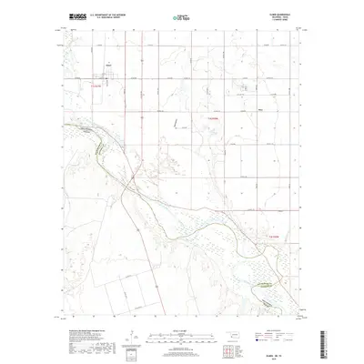
2019 Map of Elmer
USGS Topo · Published 2019About this map
Elmer sits at the northern edge of this landscape, its grid organized around Main St and Neville Ave. This region of Jackson County is defined by the sweeping transition of the Red River, which forms a complex braided channel and border between Oklahoma and Texas. To the east, the small settlement of Hess serves as a local landmark, anchored by the Hess Cem on its northern outskirts. The convergence of the Salt Fork Red River with the main river channel creates a broad, shifting floodplain that dominates the southern and western portions of the map. This area's drainage pattern, including the distinctive Red Hollow, illustrates the hydrologic character of the borderlands where the terrain slopes toward the expansive riverbed, showing the relationship between small agricultural centers and the major watercourse that shapes the state line.
Find a feature on this map
42 named features on this map. Tap any name to fly to it.
Don’t see what you’re looking for? This feature index may not catch every label — zoom into the map to look around manually.
Map Details
Editions of this 2019 Elmer Map
This is the sole edition of this map. No revisions or reprints were ever made.
Other maps of this area

1955 · Lawton
USGS Topo · 1:250,000
1958 · Frederick
USGS Topo · 1:62,500
1958 · Elmer
USGS Topo · 1:62,500
1963 · Altus SE
USGS Topo · 1:24,000
1964 · Tipton
USGS Topo · 1:24,000
1964 · Olustee
USGS Topo · 1:24,000
1975 · Elmore City NE
USGS Topo · 1:24,000
1975 · Frederick SW
USGS Topo · 1:24,000
1975 · Frederick NW
USGS Topo · 1:24,000
1984 · Elmer
USGS Topo · 1:24,000