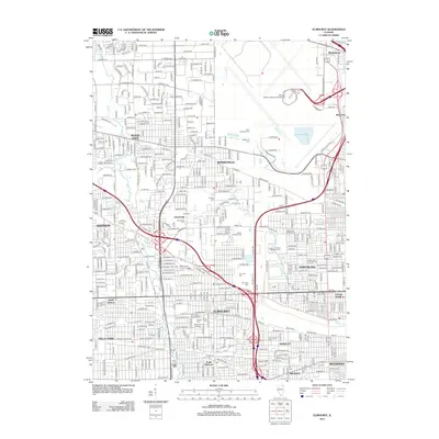
2012 Map of Elmhurst
USGS Topo · Published 2012About this map
O'Hare International Airport dominates the northeast quadrant of this DuPage and Cook County landscape, illustrating the intricate intersection of massive transportation infrastructure and established residential communities. The map highlights a high density of memorial sites and educational institutions, including Elmhurst College and McCormac Junior College. Local history is preserved in spaces like the Old Settlers Cem and Saint Johannes Cem, which sit alongside modern developments in Bensenville and Elmhurst. The hydrological network, defined by Salt Creek and the Bensenville Ditch, maneuvers through a grid of significant corridors like Grand Avenue and Pratt Blvd. This survey documents the mature suburban fabric where industrial zones near Wood Dale and Northlake meet the quiet boundaries of the Mount Emblem Cem and Fairview Memorial Cem.
Find a feature on this map
83 named features on this map. Tap any name to fly to it.
Don’t see what you’re looking for? This feature index may not catch every label — zoom into the map to look around manually.
Map Details
Editions of this 2012 Elmhurst Map
This is the sole edition of this map. No revisions or reprints were ever made.
Other maps of this area

1891 · Riverside
USGS Topo · 1:62,500

1893 · Riverside
USGS Topo · 1:62,500

1900 · Riverside
USGS Topo · 1:62,500

1900 · Highwood
USGS Topo · 1:62,500

1901 · Riverside
USGS Topo · 1:62,500

1908 · Wheaton
USGS Topo · 1:62,500

1923 · Barrington
USGS Topo · 1:62,500
1927 · Hinsdale
USGS Topo · 1:24,000

1927 · Arlington Heights
USGS Topo · 1:24,000

1928 · Elmhurst
USGS Topo · 1:24,000