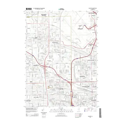
2015 Map of Elmhurst
USGS Topo · Published 2015About this map
Chicago O'Hare International Airport dominates the northeastern landscape of this region, serving as a massive industrial and transportation hub at the border of Cook and DuPage counties. The surrounding suburban fabric is densely interconnected by a complex grid of thoroughfares like W Irving Park Rd and Thorndale Ave, which link established communities including Bensenville, Elmhurst, and Franklin Park.
Find a feature on this map
195 named features on this map. Tap any name to fly to it.
Don’t see what you’re looking for? This feature index may not catch every label — zoom into the map to look around manually.
Map Details
Editions of this 2015 Elmhurst Map
This is the sole edition of this map. No revisions or reprints were ever made.
Other maps of this area

1891 · Riverside
USGS Topo · 1:62,500

1893 · Riverside
USGS Topo · 1:62,500

1900 · Riverside
USGS Topo · 1:62,500

1900 · Highwood
USGS Topo · 1:62,500

1901 · Riverside
USGS Topo · 1:62,500

1908 · Wheaton
USGS Topo · 1:62,500

1923 · Barrington
USGS Topo · 1:62,500
1927 · Hinsdale
USGS Topo · 1:24,000

1927 · Arlington Heights
USGS Topo · 1:24,000

1928 · Elmhurst
USGS Topo · 1:24,000