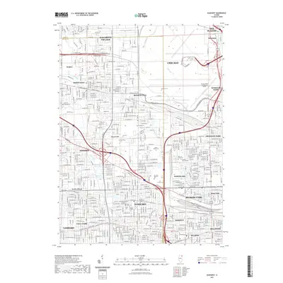
2021 Map of Elmhurst
USGS Topo · Published 2021About this map
Elmhurst and its surrounding suburban corridor appear here as a dense network of residential streets and essential green spaces along the Cook and DuPage County line. The landscape is defined by its transit history and community hubs, anchored by Elmhurst College and the recreational stretch of the Illinois Prairie Path Main Stem-Trl. Waterways like Salt Creek and Addison Creek thread through the built environment, connecting various parks and preserves.
Find a feature on this map
75 named features on this map. Tap any name to fly to it.
Don’t see what you’re looking for? This feature index may not catch every label — zoom into the map to look around manually.
Map Details
Editions of this 2021 Elmhurst Map
This is the sole edition of this map. No revisions or reprints were ever made.
Other maps of this area

1891 · Riverside
USGS Topo · 1:62,500

1893 · Riverside
USGS Topo · 1:62,500

1900 · Riverside
USGS Topo · 1:62,500

1900 · Highwood
USGS Topo · 1:62,500

1901 · Riverside
USGS Topo · 1:62,500

1908 · Wheaton
USGS Topo · 1:62,500

1923 · Barrington
USGS Topo · 1:62,500
1927 · Hinsdale
USGS Topo · 1:24,000

1927 · Arlington Heights
USGS Topo · 1:24,000

1928 · Elmhurst
USGS Topo · 1:24,000