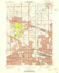
1953 Map of Elmhurst
USGS Topo · Published 1956About this map
O'Hare Field Chicago International Airport occupies the northeast corner of this mid-century landscape, a massive footprint that signals the rapid postwar transition of the Chicago suburbs. This era of expansion is evidenced by the dense grid of residential streets pushing outward from established hubs like Elmhurst, Bensenville, and Villa Park. While aviation dominates the north with additional facilities like Elmhurst Airport and Sky Haven Airport, the southern reaches remain anchored by institutional landmarks such as Elmhurst College and the Mater Dolorosa Seminary.
Find a feature on this map
103 named features on this map. Tap any name to fly to it.
Don’t see what you’re looking for? This feature index may not catch every label — zoom into the map to look around manually.
Map Details
Editions of this 1953 Elmhurst Map
This is the sole edition of this map. No revisions or reprints were ever made.
Other maps of this area

1891 · Riverside
USGS Topo · 1:62,500

1893 · Riverside
USGS Topo · 1:62,500

1900 · Riverside
USGS Topo · 1:62,500

1900 · Highwood
USGS Topo · 1:62,500

1901 · Riverside
USGS Topo · 1:62,500

1908 · Wheaton
USGS Topo · 1:62,500

1923 · Barrington
USGS Topo · 1:62,500
1927 · Hinsdale
USGS Topo · 1:24,000

1927 · Arlington Heights
USGS Topo · 1:24,000

1928 · Elmhurst
USGS Topo · 1:24,000