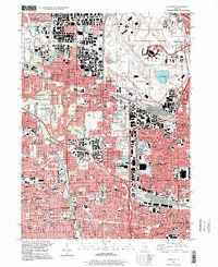
1997 Map of Elmhurst
USGS Topo · Published 1999About this map
Elmhurst and Bensenville anchor this detailed study of the suburban landscape on the border of Cook and Du Page counties during the late 1990s. The eastern portion is dominated by the sprawling infrastructure of Chicago O'Hare International Airport, including Lake O'Hare and various support facilities. This era captures the dense residential and industrial grid expanding around the airport, with numerous schools and religious institutions serving the growing population, such as Elmhurst College and Immaculate Conception Church.
Find a feature on this map
83 named features on this map. Tap any name to fly to it.
Don’t see what you’re looking for? This feature index may not catch every label — zoom into the map to look around manually.
Map Details
Editions of this 1997 Elmhurst Map
This is the sole edition of this map. No revisions or reprints were ever made.
Other maps of this area

1891 · Riverside
USGS Topo · 1:62,500

1893 · Riverside
USGS Topo · 1:62,500

1900 · Riverside
USGS Topo · 1:62,500

1900 · Highwood
USGS Topo · 1:62,500

1901 · Riverside
USGS Topo · 1:62,500

1908 · Wheaton
USGS Topo · 1:62,500

1923 · Barrington
USGS Topo · 1:62,500
1927 · Hinsdale
USGS Topo · 1:24,000

1927 · Arlington Heights
USGS Topo · 1:24,000

1928 · Elmhurst
USGS Topo · 1:24,000