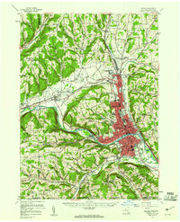
1953 Map of Elmira
USGS Topo · Published 1961About this map
The Chemung River valley anchors this mid-century portrait of Chemung County, where industrial centers meet the steep, wooded hills of the Southern Tier. Elmira and Elmira Heights dominate the central valley, showing the dense urban grid of the era alongside landmarks like Elmira College and the Mark Twain Study. To the north, the town of Horseheads serves as a critical junction for the Erie Lackawanna and Pennsylvania railroads, which parallel Newtown Creek and the valley floors.
Find a feature on this map
103 named features on this map. Tap any name to fly to it.
Don’t see what you’re looking for? This feature index may not catch every label — zoom into the map to look around manually.
Map Details
Editions of this 1953 Elmira Map
2 editions found
Other maps of this area

1893 · Ithaca
USGS Topo · 1:62,500

1895 · Ithaca
USGS Topo · 1:62,500

1895 · Elmira
USGS Topo · 1:62,500

1898 · Watkins Glen
USGS Topo · 1:62,500

1900 · Tioga
USGS Topo · 1:62,500

1901 · Watkins
USGS Topo · 1:62,500

1902 · Waverly
USGS Topo · 1:62,500

1902 · Tioga
USGS Topo · 1:62,500

1903 · Hammondsport
USGS Topo · 1:62,500

1905 · Watkins Glen
USGS Topo · 1:125,000