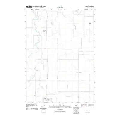
2010 Map of Elmore
USGS Topo · Published 2010About this map
The Blue Earth River and its multiple branches define the agrarian landscape of southern Faribault County in this 2010 survey. The settlement of Elmore sits at the southern edge of the map near the Iowa border, serving as a focal point for the surrounding rural area with the Elmore Post Office and nearby Riverview Cemetery. The landscape is intricately partitioned by a grid of numbered roads and an extensive network of managed waterways, including Judicial Ditch Number Thirteen and County Ditch Number Fortyone, reflecting the area's long-standing reliance on engineered drainage for agricultural productivity.
Find a feature on this map
42 named features on this map. Tap any name to fly to it.
Don’t see what you’re looking for? This feature index may not catch every label — zoom into the map to look around manually.
Map Details
Editions of this 2010 Elmore Map
This is the sole edition of this map. No revisions or reprints were ever made.
Other maps of this area

1954 · Fairmont
USGS Topo · 1:250,000

1954 · Mason City
USGS Topo · 1:250,000

1955 · Bricelyn
USGS Topo · 1:62,500

1957 · Mason City
USGS Topo · 1:250,000

1958 · Mason City
USGS Topo · 1:250,000

1958 · Fairmont
USGS Topo · 1:250,000

1967 · Pilot Grove
USGS Topo · 1:24,000

1967 · Elmore
USGS Topo · 1:24,000

1967 · Huntley
USGS Topo · 1:24,000
1967 · Blue Earth
USGS Topo · 1:24,000