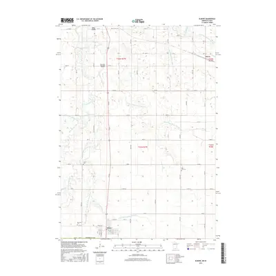
2016 Map of Elmore
USGS Topo · Published 2016About this map
The confluence of agricultural engineering and river geography defines this portion of Faribault Co, where the Blue Earth River and its western and middle branches wind through the prairie landscape. The town of Elmore sits at the southern edge of the survey, serving as a hub for the local farming community near the state line. Further north, the settlement of Marna and the southern outskirts of Blue Earth anchor the map's northern boundary near the Blue Earth Municipal Airport.
Find a feature on this map
40 named features on this map. Tap any name to fly to it.
Don’t see what you’re looking for? This feature index may not catch every label — zoom into the map to look around manually.
Map Details
Editions of this 2016 Elmore Map
This is the sole edition of this map. No revisions or reprints were ever made.
Other maps of this area

1954 · Fairmont
USGS Topo · 1:250,000

1954 · Mason City
USGS Topo · 1:250,000

1955 · Bricelyn
USGS Topo · 1:62,500

1957 · Mason City
USGS Topo · 1:250,000

1958 · Mason City
USGS Topo · 1:250,000

1958 · Fairmont
USGS Topo · 1:250,000

1967 · Pilot Grove
USGS Topo · 1:24,000

1967 · Elmore
USGS Topo · 1:24,000

1967 · Huntley
USGS Topo · 1:24,000
1967 · Blue Earth
USGS Topo · 1:24,000