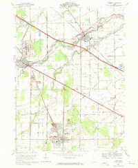
1969 Map of Elmore
USGS Topo · Published 1971About this map
The Portage River winds through Northwest Ohio, anchoring the industrial and agricultural landscape of Ottawa and Sandusky Counties in the late 1960s. The village of Elmore and nearby Woodville serve as central hubs along the Penn Central railroad, while Gibsonburg marks the southern edge of this detailed survey. Extensive oil production is evident across the terrain, with numerous Oil Wells scattered near Aldrich Pond and the surrounding rural townships. The infrastructure of the era is prominently displayed through the Ohio Toll Turnpike cutting across the north, and a local Drive-in Theater situated near Busy Corners. Notable local institutions including the Woodmore High Sch and several well-established burial grounds like Veterans Mem Cem and West Union Cem provide significant landmarks for genealogical research and local history studies.
Find a feature on this map
60 named features on this map. Tap any name to fly to it.
Don’t see what you’re looking for? This feature index may not catch every label — zoom into the map to look around manually.
Map Details
Editions of this 1969 Elmore Map
2 editions found
Other maps of this area

1900 · Maumee Bay
USGS Topo · 1:62,500

1900 · Oak Harbor
USGS Topo · 1:62,500

1901 · Fremont
USGS Topo · 1:62,500

1901 · Elmore
USGS Topo · 1:62,500

1903 · Fremont
USGS Topo · 1:62,500

1903 · Elmore
USGS Topo · 1:62,500

1935 · Walbridge
USGS Topo · 1:24,000

1935 · Genoa
USGS Topo · 1:24,000

1938 · Walbridge
USGS Topo · 1:31,680
1938 · Genoa
USGS Topo · 1:31,680