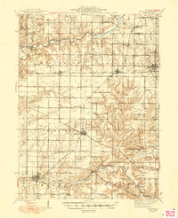
1948 Map of Elmwood
USGS Topo · Published 1948About this map
Jubilee College State Park and the rugged drainage of Kickapoo Creek anchor the eastern landscape of this mid-century topographic study. The area is defined by a dense network of early rural schoolhouses, including Nightingale Sch, Bramble Sch, and Maple Grove Sch, reflecting the community-centric settlement pattern of central Illinois. Major rail corridors including the Atchison Topeka and Santa Fe and the Chicago Burlington and Quincy converge near the towns of Princeville and Monica, showing the importance of these transit links to the local agricultural economy. The western edge follows the winding course of the Spoon River, where small hamlets like Laura and Brimfield appear amidst a landscape dotted with family cemeteries such as Glendale Cem and Southport Cem. This survey provides a precise look at Peoria County's township divisions just after the war.
Find a feature on this map
72 named features on this map. Tap any name to fly to it.
Don’t see what you’re looking for? This feature index may not catch every label — zoom into the map to look around manually.
Map Details
Editions of this 1948 Elmwood Map
2 editions found

Other maps of this area

1893 · Dunlap
USGS Topo · 1:62,500

1898 · Dunlap
USGS Topo · 1:62,500

1905 · Peoria
USGS Topo · 1:62,500

1912 · Canton
USGS Topo · 1:62,500

1927 · Peoria
USGS Topo · 1:62,500

1930 · Glasford
USGS Topo · 1:62,500

1931 · Galva
USGS Topo · 1:48,000

1932 · Dunlap
USGS Topo · 1:62,500

1933 · Dunlap
USGS Topo · 1:62,500

1933 · Camp Grove
USGS Topo · 1:48,000