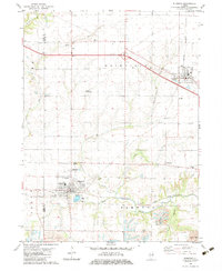
1982 Map of Elmwood
USGS Topo · Published 1983About this map
The Knox Co Peoria Co line bisects this portion of the Illinois prairie, where the Burlington Northern railroad serves as the primary artery for the communities of Elmwood and Brimfield. The landscape reflects a mix of established agricultural settlements and industrial activity, notably the heavy Strip Mine operations and a Gravel Pit along the West Fork Kickapoo Creek. Genealogists will find several burial grounds documented, including St Marys Cem, Southport Cem, and Lehigh Cem, which anchor the smaller hamlets and rural crossroads.
Find a feature on this map
34 named features on this map. Tap any name to fly to it.
Don’t see what you’re looking for? This feature index may not catch every label — zoom into the map to look around manually.
Map Details
Editions of this 1982 Elmwood Map
This is the sole edition of this map. No revisions or reprints were ever made.
Other maps of this area

1912 · Canton
USGS Topo · 1:62,500

1930 · Glasford
USGS Topo · 1:62,500

1941 · Maquon
USGS Topo · 1:62,500

1943 · Maquon
USGS Topo · 1:62,500

1944 · Elmwood
USGS Topo · 1:62,500

1948 · Elmwood
USGS Topo · 1:62,500

1948 · Glasford
USGS Topo · 1:62,500

1958 · Burlington
USGS Topo · 1:250,000

1958 · Peoria
USGS Topo · 1:250,000

1961 · Burlington
USGS Topo · 1:250,000