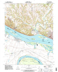
1991 Map of Elsah
USGS Topo · Published 1995About this map
Mississippi River waters dominate this landscape, where the confluence with the Missouri River shapes a complex network of channels, levees, and silt-heavy islands. Along the Illinois bluffs, the village of Elsah and the campus of Principle College overlook the river's wide expanse and the prominent Elsah Bar. The Missouri side reveals a low-lying floodplain protected by an extensive levee system, where small rail-side settlements like Machens and Whitecorn sit among backwater features like Weber Lake and Poeling Lake.
Find a feature on this map
35 named features on this map. Tap any name to fly to it.
Don’t see what you’re looking for? This feature index may not catch every label — zoom into the map to look around manually.
Map Details
Editions of this 1991 Elsah Map
This is the sole edition of this map. No revisions or reprints were ever made.
Other maps of this area

1924 · Robertson
USGS Topo · 1:24,000

1925 · Brighton
USGS Topo · 1:62,500

1927 · Alton
USGS Topo · 1:62,500

1927 · St. Charles
USGS Topo · 1:62,500

1928 · Brighton
USGS Topo · 1:62,500

1930 · Jerseyville
USGS Topo · 1:62,500

1933 · Jerseyville
USGS Topo · 1:62,500

1933 · Saint Charles
USGS Topo · 1:62,500

1934 · Alton
USGS Topo · 1:62,500

1935 · Florissant
USGS Topo · 1:24,000