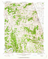
1934 Map of Elsberry
USGS Topo · Published 1963About this map
Elsberry stands as the primary hub along the Chicago Burlington and Quincy railroad, situated between the high bluffs and the fertile bottomlands of Kings Lake. This 1930s landscape reveals a dense network of rural infrastructure, from the U S Erosion Farm to the numerous one-room schools like Barton Sch and Hickory Ridge Sch that served the surrounding townships. The transition from the rugged terrain of Hurricane and Snow Hill down to the Cuivre River floodplains is marked by long-standing communities such as Old Alexandria and Auburn. Significant conservation and research efforts are evident through the early development of Cuivre River State Park and the U S Experiment Farm, reflecting the era's focus on land management and natural resources. For genealogists, the map captures a wealth of family-named landmarks and country churches, including Smith Chapel and Ashburn Chapel, preserved at a moment before mid-century modernization altered the local landscape.
Find a feature on this map
93 named features on this map. Tap any name to fly to it.
Don’t see what you’re looking for? This feature index may not catch every label — zoom into the map to look around manually.
Map Details
Editions of this 1934 Elsberry Map
2 editions found
Other maps of this area

1890 · Louisiana
USGS Topo · 1:125,000

1890 · Hermann
USGS Topo · 1:125,000

1903 · O'Fallon
USGS Topo · 1:125,000

1930 · Pearl
USGS Topo · 1:62,500

1930 · Nebo
USGS Topo · 1:62,500

1930 · Hardin
USGS Topo · 1:62,500

1931 · Brussels
USGS Topo · 1:62,500

1934 · Nebo
USGS Topo · 1:48,000

1934 · Elsberry
USGS Topo · 1:48,000

1934 · Hardin
USGS Topo · 1:62,500