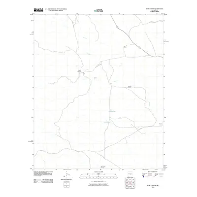
2010 Map of Elsie Canyon
USGS Topo · Published 2010About this map
Salt Creek winds through this arid drainage system in Chaves County, anchoring a landscape defined by ranching life and seasonal water sources. The map records the essential infrastructure of the American Southwest at the turn of the 21st century, where the Salt Creek Ranch and Porter Ranch serve as primary human outposts amidst a network of intricate drainages. The terrain is marked by significant topographical features such as Elsie Canyon, Catclaw Canyon, and Blackwater Canyon, while Antelope Lake and Chimney Lake provide rare catchments in an otherwise thirsty environment. Transport is facilitated by graded paths including County Rd-A048 and Draper Rd, which connect these isolated holdings. Strategic landmarks like the Sand Windmill highlight the ongoing importance of water management for livestock in this high-desert setting.
Find a feature on this map
20 named features on this map. Tap any name to fly to it.
Don’t see what you’re looking for? This feature index may not catch every label — zoom into the map to look around manually.
Map Details
Editions of this 2010 Elsie Canyon Map
This is the sole edition of this map. No revisions or reprints were ever made.
Other maps of this area

1936 · Arabela
USGS Topo · 1:48,000

1942 · Arabela
USGS Topo · 1:62,500

1955 · Roswell
USGS Topo · 1:250,000

1958 · Roswell
USGS Topo · 1:250,000

1961 · Tinnie
USGS Topo · 1:62,500

1962 · Roswell
USGS Topo · 1:250,000

1962 · Horseshoe Bend
USGS Topo · 1:62,500

1967 · White Flat
USGS Topo · 1:24,000
1967 · White Flat SE
USGS Topo · 1:24,000
1967 · Elsie Canyon
USGS Topo · 1:24,000