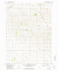
1980 Map of Elwood
USGS Topo · Published 1981About this map
Elwood sits at the northwestern edge of this landscape, a small community defined by its connection to the Chicago Milwaukee St Paul and Pacific railroad. The terrain is divided into the large townships of Brookfield, Bloomfield, Grant, and Welton, reflecting the organized agricultural layout of Clinton County. Waterways like Deep Creek and Spring Silver Creek wind through the hills, punctuated by local landmarks like the Drive-in Theater and Bloomfield Park.
Find a feature on this map
17 named features on this map. Tap any name to fly to it.
Don’t see what you’re looking for? This feature index may not catch every label — zoom into the map to look around manually.
Map Details
Editions of this 1980 Elwood Map
This is the sole edition of this map. No revisions or reprints were ever made.
Other maps of this area

1891 · DeWitt
USGS Topo · 1:62,500

1891 · Maquoketa
USGS Topo · 1:62,500

1891 · Baldwin
USGS Topo · 1:62,500

1892 · Wheatland
USGS Topo · 1:62,500

1894 · Wheatland
USGS Topo · 1:62,500

1901 · Peosta
USGS Topo · 1:125,000

1901 · Rock Island
USGS Topo · 1:125,000

1910 · Rock Island
USGS Topo · 1:125,000
1953 · De Witt
USGS Topo · 1:24,000
1953 · Grand Mound
USGS Topo · 1:24,000