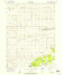
1953 Map of Grand Mound
USGS Topo · Published 1958About this map
The Chicago and Northwestern railroad serves as the primary east-west corridor for this Clinton County landscape, anchoring the settlement of Grand Mound. The surrounding township lands, including Grant and Olive, are defined by a network of rural schoolhouses and family-named landmarks that reflect a mid-century agricultural community. Educational centers like Griebel School and Stemple School dot the countryside north of the tracks, while Grand Field Airport provides a small aviation hub near Barber Creek. In the southern reaches, the Wapsipinicon River meanders along the Clinton Scott Co boundary line. This area is particularly rich for genealogical research, featuring numerous burial grounds including Evergreen Cemetery, Kvindhered Cemetery, and Emmanuel Cemetery, alongside community focal points like Our Saviors Church.
Find a feature on this map
25 named features on this map. Tap any name to fly to it.
Don’t see what you’re looking for? This feature index may not catch every label — zoom into the map to look around manually.
Map Details
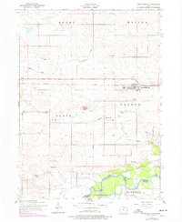
Editions of this 1953 Grand Mound Map
2 editions found
Other maps of this area

1890 · Durant
USGS Topo · 1:62,500

1891 · DeWitt
USGS Topo · 1:62,500

1891 · Davenport
USGS Topo · 1:62,500

1892 · Wheatland
USGS Topo · 1:62,500

1894 · Wheatland
USGS Topo · 1:62,500

1894 · Durant
USGS Topo · 1:62,500

1894 · Davenport
USGS Topo · 1:62,500

1901 · Rock Island
USGS Topo · 1:125,000

1910 · Rock Island
USGS Topo · 1:125,000
1953 · De Witt
USGS Topo · 1:24,000