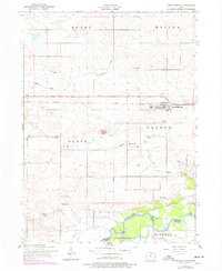
1953 Map of Grand Mound
USGS Topo · Published 1977About this map
The town of Grand Mound sits at the center of this rural Iowa landscape, established along the Chicago and Northwestern railroad line. The map highlights a deeply rooted agricultural community through its numerous rural schools and country churches, such as Our Saviors Church and the Meints School. The southern edge of the survey is defined by the winding course of the Wapsipinicon River and the wooded bottomlands of Allens Grove, providing a sharp contrast to the geometric section lines that organize the surrounding townships of Grant, Welton, Olive, and Orange.
Find a feature on this map
27 named features on this map. Tap any name to fly to it.
Don’t see what you’re looking for? This feature index may not catch every label — zoom into the map to look around manually.
Map Details
Editions of this 1953 Grand Mound Map
2 editions found
Other maps of this area

1890 · Durant
USGS Topo · 1:62,500

1891 · DeWitt
USGS Topo · 1:62,500

1891 · Davenport
USGS Topo · 1:62,500

1892 · Wheatland
USGS Topo · 1:62,500

1894 · Wheatland
USGS Topo · 1:62,500

1894 · Durant
USGS Topo · 1:62,500

1894 · Davenport
USGS Topo · 1:62,500

1901 · Rock Island
USGS Topo · 1:125,000

1910 · Rock Island
USGS Topo · 1:125,000
1953 · De Witt
USGS Topo · 1:24,000