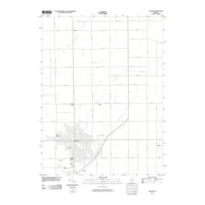
2010 Map of Elwood
USGS Topo · Published 2010About this map
Elwood serves as the primary hub in this central Indiana landscape, surrounded by a network of smaller communities including South Elwood, West Elwood, and the outlying settlement of Leisure. The grid-like agricultural roads are interrupted by the meandering courses of Big Duck Creek and Little Duck Creek, which drain the flat terrain. Local genealogists will find significant detail in the multiple burial grounds, such as Carr Cemetery, Waymire Cemetery, and Saint Josephs Cemetery, which are scattered between the town center and the rural periphery. The infrastructure of the early 21st century is well-defined, showing the Elwood Airport south of the city and the proximity of Dundee to the east. This survey documents the intersection of rural heritage and municipal development, where historic names like College Corner persist alongside modern landmarks like Sunset Memorial Park.
Find a feature on this map
54 named features on this map. Tap any name to fly to it.
Don’t see what you’re looking for? This feature index may not catch every label — zoom into the map to look around manually.
Map Details
Editions of this 2010 Elwood Map
This is the sole edition of this map. No revisions or reprints were ever made.
Other maps of this area

1953 · Muncie
USGS Topo · 1:250,000

1956 · Muncie
USGS Topo · 1:250,000

1960 · Elwood
USGS Topo · 1:24,000

1960 · Point Isabel
USGS Topo · 1:24,000

1960 · Alexandria
USGS Topo · 1:24,000

1960 · Fairmount
USGS Topo · 1:24,000

1960 · Windfall
USGS Topo · 1:24,000

1960 · Greentown
USGS Topo · 1:24,000

1960 · Anderson North
USGS Topo · 1:24,000
1961 · Omega
USGS Topo · 1:24,000