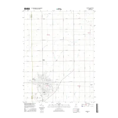
2016 Map of Elwood
USGS Topo · Published 2016About this map
Elwood and its surrounding agricultural outskirts in Madison and Tipton counties appear here during the mid-2010s, showing a landscape defined by its grid of rural roads and an extensive network of managed waterways. The city center is surrounded by satellite developments such as West Elwood, South Elwood, and College Corner, while the small community of Dundee sits to the east. The terrain is heavily modified for drainage, as evidenced by the numerous named channels like Hoppenrath Ditch, Todd Ditch, and McClure Ditch that feed into Big Duck Cr. Local history is preserved through several well-marked burial grounds, including Waymire Cem and Saint Josephs Cem, alongside the contemporary Sunset Memorial Park. This survey captures the region's enduring character as a Midwestern hub where town life and industrial-scale drainage systems meet on the Indiana plains.
Find a feature on this map
64 named features on this map. Tap any name to fly to it.
Don’t see what you’re looking for? This feature index may not catch every label — zoom into the map to look around manually.
Map Details
Editions of this 2016 Elwood Map
This is the sole edition of this map. No revisions or reprints were ever made.
Other maps of this area

1953 · Muncie
USGS Topo · 1:250,000

1956 · Muncie
USGS Topo · 1:250,000

1960 · Elwood
USGS Topo · 1:24,000

1960 · Point Isabel
USGS Topo · 1:24,000

1960 · Alexandria
USGS Topo · 1:24,000

1960 · Fairmount
USGS Topo · 1:24,000

1960 · Windfall
USGS Topo · 1:24,000

1960 · Greentown
USGS Topo · 1:24,000

1960 · Anderson North
USGS Topo · 1:24,000
1961 · Omega
USGS Topo · 1:24,000