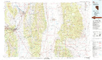
1987 Map of Ely
USGS Topo · Published 1988About this map
The high desert basins and massive mountain ranges of eastern Nevada are documented here during the late 1980s, anchored by the mining and transportation hub of Ely. This landscape is defined by its north-south orientation, where the Egan Range and Schell Creek Range frame the wide expanse of Steptoe Valley. The Nevada Northern RR reflects the region's industrial heritage, connecting the copper-rich districts around East Ely to the broader rail network. To the east, the newly established Great Basin National Park encompasses the dramatic heights of Wheeler Peak. Traces of the territory's earlier mining boom are found at the Piermont Mine and Taylor Mine, while small agricultural and ranching outposts like Baker and Garrison mark the borderlands where the terrain drops into the Snake Valley and crosses into Utah.
Find a feature on this map
73 named features on this map. Tap any name to fly to it.
Don’t see what you’re looking for? This feature index may not catch every label — zoom into the map to look around manually.
Map Details
Editions of this 1987 Ely Map
2 editions found
Other maps of this area

1908 · Fish Springs
USGS Topo · 1:250,000

1910 · Fish Springs
USGS Topo · 1:250,000

1948 · Wheeler Peak
USGS Topo · 1:62,500

1949 · Garrison
USGS Topo · 1:62,500

1950 · Wheeler Peak
USGS Topo · 1:62,500

1951 · Garrison
USGS Topo · 1:62,500

1952 · Ely
USGS Topo · 1:125,000

1953 · Richfield
USGS Topo · 1:250,000

1953 · Delta
USGS Topo · 1:250,000

1956 · Lund
USGS Topo · 1:250,000