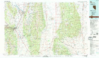
1987 Map of Ely
USGS Topo · Published 1987About this map
Ely and the surrounding high desert of White Pine County are documented here during a period of significant mining activity and conservation transitions. Massive open-pit operations like Ruth Pit, Liberty Pit, and Tripp Pit dominate the landscape near Ruth, illustrating the region's deep industrial heritage. The Nevada Northern RR provides a critical transportation link through Steptoe Valley, connecting the copper centers of Lane City and Keystone Junction with the smelter town of McGill.
Find a feature on this map
66 named features on this map. Tap any name to fly to it.
Don’t see what you’re looking for? This feature index may not catch every label — zoom into the map to look around manually.
Map Details
Editions of this 1987 Ely Map
2 editions found
Other maps of this area

1908 · Fish Springs
USGS Topo · 1:250,000

1910 · Fish Springs
USGS Topo · 1:250,000

1948 · Wheeler Peak
USGS Topo · 1:62,500

1949 · Garrison
USGS Topo · 1:62,500

1950 · Wheeler Peak
USGS Topo · 1:62,500

1951 · Garrison
USGS Topo · 1:62,500

1952 · Ely
USGS Topo · 1:125,000

1953 · Richfield
USGS Topo · 1:250,000

1953 · Delta
USGS Topo · 1:250,000

1956 · Lund
USGS Topo · 1:250,000