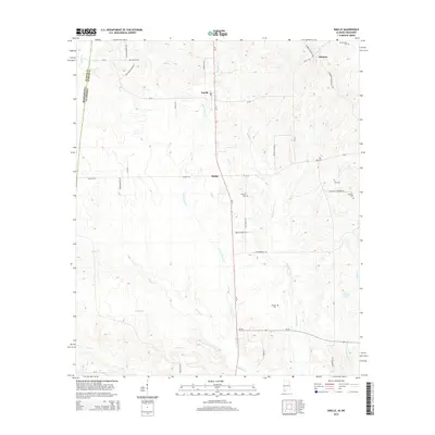
2014 Map of Emelle
USGS Topo · Published 2014About this map
Emelle serves as a central point in this part of Sumter County, where the landscape is defined by the winding paths of Sicolocco Cr and the Little Sanusi Cr. The 2014 survey reveals a rural area with deep genealogical roots, marked by numerous small burial grounds such as Boney Cem, Bell Cem, and Old Side Cem. Settlement patterns follow the corridors of Al-17 and Al-28, connecting smaller locales like Sledge and Hamner to the surrounding timber and farm lands. To the southeast, the terrain reaches toward the C E Boyd Lake and the drainage basin of Miuka Cr. This map is particularly valuable for researchers tracing family landmarks along historic routes like Old Sides Cemetery Rd and Buck Boyd Rd, offering a precise record of the contemporary Alabama-Mississippi borderlands.
Find a feature on this map
45 named features on this map. Tap any name to fly to it.
Don’t see what you’re looking for? This feature index may not catch every label — zoom into the map to look around manually.
Map Details
Editions of this 2014 Emelle Map
This is the sole edition of this map. No revisions or reprints were ever made.
Other maps of this area

1929 · Epes
USGS Topo · 1:48,000

1932 · Epes
USGS Topo · 1:62,500

1953 · Meridian
USGS Topo · 1:250,000

1957 · Meridian
USGS Topo · 1:250,000

1965 · Meridian
USGS Topo · 1:250,000

1970 · Gainesville
USGS Topo · 1:24,000

1973 · Scooba
USGS Topo · 1:24,000
1973 · Geiger
USGS Topo · 1:24,000

1974 · Boyd
USGS Topo · 1:24,000
1974 · Tamola
USGS Topo · 1:24,000