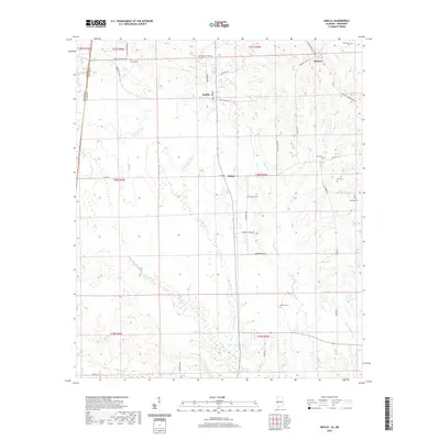
2020 Map of Emelle
USGS Topo · Published 2020About this map
Emelle and the surrounding timberlands of Sumter County are defined by an intricate network of creeks and family-named landmarks near the Mississippi border. This region is a study in rural Alabama settlement patterns, where small communities like Sledge and Hamner serve as focal points for a landscape carved by the Sanusi Cr and Little Sanusi Cr drainage systems. The map reveals a high density of small family or community burial grounds, including Boney Cem, Hutchenson Cem, and Old Side Cem, providing significant geographical anchors for genealogists and local historians. North of C E Boyd Lake, the terrain is marked by a grid of rural routes such as Hammer Sumterville Rd and Looksookolo Rd, which connect the scattered homesteads and agricultural plots that have sustained this corner of the state for generations.
Find a feature on this map
46 named features on this map. Tap any name to fly to it.
Don’t see what you’re looking for? This feature index may not catch every label — zoom into the map to look around manually.
Map Details
Editions of this 2020 Emelle Map
This is the sole edition of this map. No revisions or reprints were ever made.
Other maps of this area

1929 · Epes
USGS Topo · 1:48,000

1932 · Epes
USGS Topo · 1:62,500

1953 · Meridian
USGS Topo · 1:250,000

1957 · Meridian
USGS Topo · 1:250,000

1965 · Meridian
USGS Topo · 1:250,000

1970 · Gainesville
USGS Topo · 1:24,000

1973 · Scooba
USGS Topo · 1:24,000
1973 · Geiger
USGS Topo · 1:24,000

1974 · Boyd
USGS Topo · 1:24,000
1974 · Tamola
USGS Topo · 1:24,000