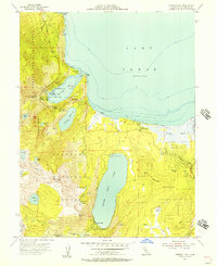
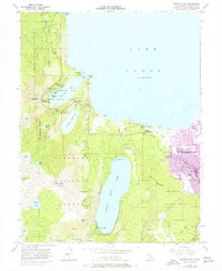
1955 Map of Emerald Bay
USGS Topo · Published 1957About this map
Vikingsholm stands as a focal point along the granite-lined shores of Emerald Bay in this mid-1950s survey of Lake Tahoe’s southwestern corner. The map captures the region’s development as a premier recreation destination, balancing protected lands like D L Bliss State Park and Emerald Bay State Park with growing lakeside settlements. Significant elevations such as Mt Tallac and Cathedral Peak tower over the deep basins of Fallen Leaf Lake and Cascade Lake. Human activity is centered around the Tahoe Valley corridor and the established grounds of Camp Richardson. Local history researchers will find the precise placement of landmarks like the Bay View Guard Station, Angora Lookout, and the historic Glen Alpine Spring valuable for documenting the evolution of forest service infrastructure and early mountain resorts before later development altered the landscape.
Find a feature on this map
58 named features on this map. Tap any name to fly to it.
Don’t see what you’re looking for? This feature index may not catch every label — zoom into the map to look around manually.
Map Details
Editions of this 1955 Emerald Bay Map
5 editions found
Other maps of this area

1889 · Pyramid Peak
USGS Topo · 1:125,000

1889 · Markleeville
USGS Topo · 1:125,000

1891 · Carson
USGS Topo · 1:125,000

1891 · Markleeville
USGS Topo · 1:125,000

1891 · Truckee
USGS Topo · 1:125,000

1891 · Pyramid Peak
USGS Topo · 1:125,000

1893 · Carson
USGS Topo · 1:125,000

1893 · Markleeville
USGS Topo · 1:125,000

1893 · Truckee
USGS Topo · 1:125,000

1895 · Pyramid Peak
USGS Topo · 1:125,000
Featured Places
- South Lake Tahoe, CA
- Tahoe Valley, South Lake Tahoe
- Camp Richardson, CA
- Kiva Beach, CA
- Tahoe Keys, South Lake Tahoe