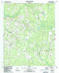
1987 Map of Emerson
USGS Topo · Published 1987About this map
The CSX rail corridor cuts through the low-lying wetlands of the coastal plain in this late 1980s landscape, connecting the rural communities of Elkton, Emerson, and Rosindale. The terrain is characterized by an intricate network of Carolina bays and swampy tributaries, including the namesake Winnie Moore Bay and Sawhorn Bay. These geological depressions create a distinct spatial pattern across the countryside, interspersed with traditional land uses such as Clark Millpond.
Find a feature on this map
55 named features on this map. Tap any name to fly to it.
Don’t see what you’re looking for? This feature index may not catch every label — zoom into the map to look around manually.
Map Details
Editions of this 1987 Emerson Map
This is the sole edition of this map. No revisions or reprints were ever made.
Other maps of this area

1953 · Florence
USGS Topo · 1:250,000

1954 · Florence
USGS Topo · 1:250,000

1954 · White Lake
USGS Topo · 1:62,500

1954 · Bolton
USGS Topo · 1:62,500

1955 · Whiteville
USGS Topo · 1:62,500

1955 · Elizabethtown
USGS Topo · 1:62,500

1982 · Elizabethtown
USGS Topo · 1:100,000
1986 · Lake Waccamaw East
USGS Topo · 1:24,000
1986 · Singletary Lake
USGS Topo · 1:24,000
1986 · Council
USGS Topo · 1:24,000