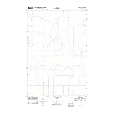
2011 Map of Emerson
USGS Topo · Published 2011About this map
Emerson stands as the primary point of settlement within this landscape of the Missouri Plateau, situated where the high plains are carved by a network of wandering waterways. The Knife River meanders across the northern half of the sheet, creating a complex series of oxbows and riparian curves that dictate the placement of the surrounding section-line roads. Feeding into this drainage system are Crooked Creek and Stray Creek, which further dissect the prairie terrain. The map reveals a highly structured rectilinear grid of rural routes, including 18th St SW and 101st Ave SW, which facilitate movement between the dispersed farmsteads of Dunn County. This 2011 survey captures the area’s enduring agricultural character, where the natural hydrology of the river valleys remains the most prominent geographic influence on the human layout of the land.
Find a feature on this map
21 named features on this map. Tap any name to fly to it.
Don’t see what you’re looking for? This feature index may not catch every label — zoom into the map to look around manually.
Map Details
Editions of this 2011 Emerson Map
This is the sole edition of this map. No revisions or reprints were ever made.
Other maps of this area

1953 · Watford City
USGS Topo · 1:250,000

1957 · Watford City
USGS Topo · 1:250,000

1967 · Watford City
USGS Topo · 1:250,000

1973 · Manning SE
USGS Topo · 1:24,000

1973 · Ziner Butte
USGS Topo · 1:24,000
1973 · Hirschville SW
USGS Topo · 1:24,000
1973 · Hirschville
USGS Topo · 1:24,000

1973 · Manning
USGS Topo · 1:24,000

1973 · Dunn Center
USGS Topo · 1:24,000

1973 · Emerson
USGS Topo · 1:24,000