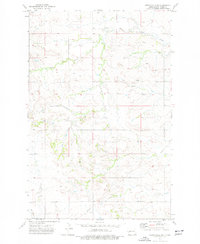
1973 Map of Hirschville SW
USGS Topo · Published 1977About this map
The high plains of Dunn County, North Dakota, are defined by an intricate network of drainage and ranching infrastructure in this mid-1970s survey. The landscape is carved by Deep Creek and the headwaters of Russian Spring Cr, which provided essential water sources in this semi-arid region. Unlike more densely populated areas, this map reveals a land utilized for its natural resources and livestock, marked by several Well sites and a Gravel Pit. The presence of a significant Pipeline cutting across the southern sections speaks to the development of the region's energy infrastructure during this era. Surveyed by the U.S. Geological Survey and the State Water Commission, the sheet preserves the locations of early rural landmarks like various unnamed Spring points that once dictated the movement of both people and cattle across the divide.
Find a feature on this map
8 named features on this map. Tap any name to fly to it.
Don’t see what you’re looking for? This feature index may not catch every label — zoom into the map to look around manually.
Map Details
Editions of this 1973 Hirschville SW Map
This is the sole edition of this map. No revisions or reprints were ever made.
Other maps of this area

1953 · Dickinson
USGS Topo · 1:250,000

1953 · Watford City
USGS Topo · 1:250,000

1957 · Dickinson
USGS Topo · 1:250,000

1957 · Watford City
USGS Topo · 1:250,000

1959 · Dickinson North
USGS Topo · 1:24,000

1962 · Davis Buttes
USGS Topo · 1:24,000

1967 · Watford City
USGS Topo · 1:250,000

1973 · Boyle
USGS Topo · 1:24,000

1973 · Manning SE
USGS Topo · 1:24,000

1973 · Ziner Butte
USGS Topo · 1:24,000