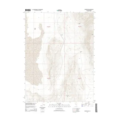
2014 Map of Emerson Pass
USGS Topo · Published 2014About this map
Sano serves as the primary focal point of this arid landscape, situated at the base of the Terraced Hills in northern Nevada. The terrain is characterized by the expansive Smoke Creek Desert to the west, an area of high desert playa and sagebrush flats. To the east, the Fox Range rises sharply, divided from the central hills by the namesake Emerson Pass. This area, documented in 2014, reveals a sparse settlement pattern dominated by topographic necessities and water sources like Soda Springs. The alignment of Mullens Canyon and the surrounding ridgelines highlights the natural corridors through which early routes and land divisions were established, offering a clear view of the geographic constraints that have shaped Washoe County's interior.
Find a feature on this map
11 named features on this map. Tap any name to fly to it.
Don’t see what you’re looking for? This feature index may not catch every label — zoom into the map to look around manually.
Map Details
Editions of this 2014 Emerson Pass Map
This is the sole edition of this map. No revisions or reprints were ever made.
Other maps of this area

1886 · Granite Range
USGS Topo · 1:250,000

1894 · Granite Range
USGS Topo · 1:250,000

1955 · Lovelock
USGS Topo · 1:250,000

1959 · Lovelock
USGS Topo · 1:250,000
1964 · The Needle Rocks
USGS Topo · 1:24,000
1964 · Astor Pass
USGS Topo · 1:24,000
1964 · Pyramid NE
USGS Topo · 1:24,000
1965 · Fox Range
USGS Topo · 1:62,500
1980 · Sand Pass
USGS Topo · 1:24,000
1981 · Sheepshead Spring
USGS Topo · 1:24,000