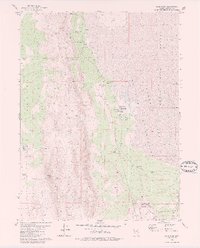
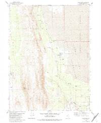
1980 Map of Sand Pass
USGS Topo · Published 1980About this map
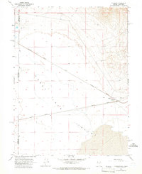
Smoke Creek Desert and the Pyramid Lake Reservation meet in this 1980 survey of the high desert terrain of Washoe County. The landscape is defined by its water sources, recorded through a series of named outflows including Laird Spring, Rotten Egg Spring, and Sulphur Spring, which were vital for the region's sparse ranching and transit activity. At Sand Pass, the Western Pacific railroad cuts through the arid basin, providing a critical transport link along the southern edge of the Terraced Hills.
Find a feature on this map
21 named features on this map. Tap any name to fly to it.
Don’t see what you’re looking for? This feature index may not catch every label — zoom into the map to look around manually.
Map Details
Editions of this 1980 Sand Pass Map
2 editions found
Other maps of this area

1886 · Granite Range
USGS Topo · 1:250,000

1894 · Granite Range
USGS Topo · 1:250,000

1955 · Lovelock
USGS Topo · 1:250,000

1959 · Lovelock
USGS Topo · 1:250,000
1964 · The Needle Rocks
USGS Topo · 1:24,000
1964 · Astor Pass
USGS Topo · 1:24,000
1964 · Flanigan
USGS Topo · 1:24,000
1965 · Fox Range
USGS Topo · 1:62,500
1980 · Red Rock Canyon
USGS Topo · 1:24,000
1980 · Parker Canyon
USGS Topo · 1:24,000