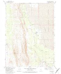
1980 Map of Sand Pass
USGS Topo · Published 1984About this map
Bonham Ranch and the small settlement of Sand Pass occupy a stark transition zone between the Smoke Creek Desert and the high ridges of Mission Peak. This 1980 survey illustrates a landscape defined by its scarce water sources, where named features such as Rotten Egg Spring, Round Hole Spring, and Laird Spring provided essential lifeblood for early ranching and transit. The western edge of the Pyramid Lake Indian Reservation is clearly delineated, showing the intersection of tribal lands with the industrial path of the Western Pacific railroad.
Find a feature on this map
21 named features on this map. Tap any name to fly to it.
Don’t see what you’re looking for? This feature index may not catch every label — zoom into the map to look around manually.
Map Details
Editions of this 1980 Sand Pass Map
2 editions found
Other maps of this area

1886 · Granite Range
USGS Topo · 1:250,000

1894 · Granite Range
USGS Topo · 1:250,000

1955 · Lovelock
USGS Topo · 1:250,000

1959 · Lovelock
USGS Topo · 1:250,000

1964 · The Needle Rocks
USGS Topo · 1:24,000
1964 · Astor Pass
USGS Topo · 1:24,000
1964 · Flanigan
USGS Topo · 1:24,000

1965 · Fox Range
USGS Topo · 1:62,500
1980 · Red Rock Canyon
USGS Topo · 1:24,000
1980 · Parker Canyon
USGS Topo · 1:24,000