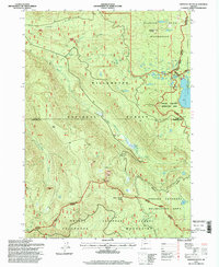
1997 Map of Emigrant Butte
USGS Topo · Published 1998About this map
Diamond Peak Wilderness and the Oregon Cascades Recreation Area dominate this high-altitude landscape in the Cascade Range, where multiple county lines and national forest boundaries converge. The topography is defined by prominent volcanic features like Emigrant Butte, Hills Peak, and Warm Spring Butte, with the Pacific Crest National Scenic Trail skirting the eastern edge near Summit Lake. Water drains through complex networks including Paddys Valley and the Middle Fork Willamette River, punctuated by numerous alpine basins such as Rockpile Lake, Marie Lake, and Hemlock Lake. The presence of several quarries and a pit in the northwest suggests limited resource extraction amidst the protected wilderness. This 1997 revision provides a precise view of the region's transition from managed timberlands in the Willamette National Forest to the strictly preserved wilderness areas of the high Cascades.
Find a feature on this map
44 named features on this map. Tap any name to fly to it.
Don’t see what you’re looking for? This feature index may not catch every label — zoom into the map to look around manually.
Map Details
Editions of this 1997 Emigrant Butte Map
This is the sole edition of this map. No revisions or reprints were ever made.
Other maps of this area

1917 · Diamond Lake
USGS Topo · 1:125,000

1925 · Waldo Lake
USGS Topo · 1:125,000

1956 · Toketee Falls
USGS Topo · 1:62,500

1956 · Waldo Lake
USGS Topo · 1:62,500

1956 · Summit Lake
USGS Topo · 1:62,500

1956 · Oakridge
USGS Topo · 1:62,500

1958 · Roseburg
USGS Topo · 1:250,000

1959 · Roseburg
USGS Topo · 1:250,000

1978 · Diamond Lake
USGS Topo · 1:100,000

1983 · Oakridge
USGS Topo · 1:100,000