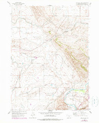
1960 Map of Emigrant Gap
USGS Topo · Published 1979About this map
The North Platte River winds through the southeastern corner of this landscape, creating the significant loop of Bessemer Bend near the landmark Red Buttes. This area preserves the tangible path of the Emigrant Trail, which cuts diagonally across the terrain toward the namesake Emigrant Gap ridge. The presence of the Old Goose Egg Ranchhouse (Ruins) and a dedicated Historical Marker points to the deep frontier heritage rooted in this river crossing.
Find a feature on this map
27 named features on this map. Tap any name to fly to it.
Don’t see what you’re looking for? This feature index may not catch every label — zoom into the map to look around manually.
Map Details
Editions of this 1960 Emigrant Gap Map
3 editions found
Other maps of this area

1950 · Emigrant Gap
USGS Topo · 1:24,000

1950 · Goose Egg
USGS Topo · 1:24,000

1950 · Emigrant Gap NE
USGS Topo · 1:24,000

1951 · Oil Mountain
USGS Topo · 1:24,000

1951 · Clarkson Hill
USGS Topo · 1:24,000

1951 · Emigrant Gap NW
USGS Topo · 1:24,000

1951 · Bessemer Mountain
USGS Topo · 1:24,000

1952 · Bishop
USGS Topo · 1:24,000

1955 · Casper
USGS Topo · 1:250,000

1958 · Casper
USGS Topo · 1:250,000