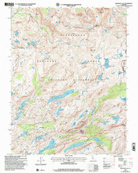
2001 Map of Emigrant Lake
USGS Topo · Published 2004About this map
Relief Peak and Kennedy Peak anchor this high-elevation landscape within the Stanislaus National Forest, as it appeared at the turn of the millennium. The survey emphasizes the transition between protected wildlands, including the Emigrant Wilderness and the northwestern edge of Yosemite National Park Wilderness. Water is the dominant feature, with the massive Emigrant Lake and High Emigrant Lake feeding into drainage systems like Cherry Creek and Summit Creek. A small cluster of prospects near the southern boundary hints at the region's mineral history, while the presence of Sheep Camp suggests seasonal grazing activity. The map is a detailed study of remote Sierra Nevada terrain, documenting the high-country crossings at Emigrant Pass and Brown Bear Pass that have guided travel through these granite basins for generations.
Find a feature on this map
61 named features on this map. Tap any name to fly to it.
Don’t see what you’re looking for? This feature index may not catch every label — zoom into the map to look around manually.
Map Details
Editions of this 2001 Emigrant Lake Map
2 editions found
Other maps of this area

1896 · Dardanelles
USGS Topo · 1:125,000

1898 · Dardanelles
USGS Topo · 1:125,000

1948 · Walker Lake
USGS Topo · 1:250,000

1954 · Pickel Meadow
USGS Topo · 1:24,000

1956 · Dardanelles Cone
USGS Topo · 1:62,500

1956 · Pinecrest
USGS Topo · 1:62,500

1956 · Sonora Pass
USGS Topo · 1:62,500
1956 · Tower Peak
USGS Topo · 1:62,500

1957 · Walker Lake
USGS Topo · 1:250,000

1962 · Walker Lake
USGS Topo · 1:250,000