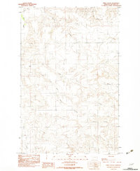
1983 Map of Emily Coulee
USGS Topo · Published 1983About this map
The high plains of McCone County are defined by an intricate network of drainage channels in this early 1980s provisional survey. Centered on Emily Coulee, the landscape is a complex system of seasonal watercourses and coulees that break the expansive Prairie. The naming conventions of the waterways, such as Big Mud Creek, Little Mud Creek, and Antelope Creek, reflect the essential relationship between the ranching economy and the scarce water resources of the region. A small Cem site is noted near the southern reaches of Emily Coulee, providing a vital point of interest for genealogists and local historians tracking early burials in this sparsely populated territory. The map also records several named landmarks such as Browns Coulee and O'Dell Coulee, which serve as primary navigational anchors in the open terrain.
Find a feature on this map
12 named features on this map. Tap any name to fly to it.
Don’t see what you’re looking for? This feature index may not catch every label — zoom into the map to look around manually.
Map Details
Editions of this 1983 Emily Coulee Map
This is the sole edition of this map. No revisions or reprints were ever made.
Other maps of this area

1915 · Oswego
USGS Topo · 1:62,500

1916 · Wolf Point
USGS Topo · 1:62,500

1954 · Glendive
USGS Topo · 1:250,000

1954 · Wolf Point
USGS Topo · 1:250,000

1957 · Glendive
USGS Topo · 1:250,000

1958 · Wolf Point
USGS Topo · 1:250,000

1958 · Glendive
USGS Topo · 1:250,000

1972 · Wolf Point
USGS Topo · 1:24,000
1972 · Flynn Creek South
USGS Topo · 1:24,000
1972 · Oswego
USGS Topo · 1:24,000