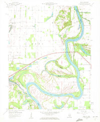
1958 Map of Emma
USGS Topo · Published 1959About this map
The Wabash River meanders dramatically along the border of Illinois and Indiana in this 1958 survey, creating a complex landscape of shifting channels and low-lying islands. Large landmasses like Greathouse Island, Hermann Island, and Cutoff Island are defined by the river's path and auxiliary waterways such as Sandy Slough and Old River. To the west, the Little Wabash River flows past the settlement of New Haven, while the northern portion of the sheet is marked by the Dogtown Hills and several Gas Wells.
Find a feature on this map
42 named features on this map. Tap any name to fly to it.
Don’t see what you’re looking for? This feature index may not catch every label — zoom into the map to look around manually.
Map Details
Editions of this 1958 Emma Map
This is the sole edition of this map. No revisions or reprints were ever made.
Other maps of this area

1903 · New Harmony
USGS Topo · 1:62,500

1903 · Patoka
USGS Topo · 1:125,000

1905 · New Haven
USGS Topo · 1:62,500

1906 · New Haven
USGS Topo · 1:62,500

1917 · Uniontown
USGS Topo · 1:62,500

1938 · New Harmony
USGS Topo · 1:62,500

1940 · Carmi
USGS Topo · 1:62,500

1943 · Carmi
USGS Topo · 1:62,500

1949 · Paducah
USGS Topo · 1:250,000

1949 · New Haven
USGS Topo · 1:62,500