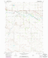
1964 Map of Emmet
USGS Topo · Published 1986About this map
The Elkhorn River meanders through this portion of Holt County, defining a landscape shaped by both natural waterways and the expansion of the Chicago and North Western railroad. The small settlement of Emmet serves as a focal point along the rail line, surrounded by a network of rural landmarks that speak to the region's mid-century development. Evidence of local industry and infrastructure is visible in the Gravel Pits and prominent Radio Towers located just west of the town center.
Find a feature on this map
9 named features on this map. Tap any name to fly to it.
Don’t see what you’re looking for? This feature index may not catch every label — zoom into the map to look around manually.
Map Details
Editions of this 1964 Emmet Map
2 editions found

Other maps of this area

1954 · Atkinson SE
USGS Topo · 1:24,000

1954 · Atkinson
USGS Topo · 1:24,000

1954 · Meek SW
USGS Topo · 1:24,000

1955 · O'Neill
USGS Topo · 1:250,000

1958 · O'Neill
USGS Topo · 1:24,000

1959 · O'Neill
USGS Topo · 1:250,000

1964 · Emmet NW
USGS Topo · 1:24,000

1964 · Emmet SE
USGS Topo · 1:24,000

1964 · Emmet SW
USGS Topo · 1:24,000

1964 · O'Neill SW
USGS Topo · 1:24,000