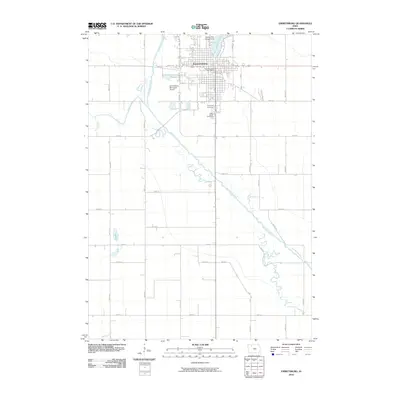
2010 Map of Emmetsburg
USGS Topo · Published 2010About this map
Emmetsburg serves as the focal point of this Palo Alto County landscape, where the urban grid meets the winding course of the Des Moines River. This 2010 survey illustrates the town's position between the river's meandering oxbows and the expansive Five Island Lake to the north. Local history is anchored by the proximity of Evergreen Cemetery and Saint Johns Cemetery, situated south of the main residential area.
Find a feature on this map
35 named features on this map. Tap any name to fly to it.
Don’t see what you’re looking for? This feature index may not catch every label — zoom into the map to look around manually.
Map Details
Editions of this 2010 Emmetsburg Map
This is the sole edition of this map. No revisions or reprints were ever made.
Other maps of this area

1954 · Fairmont
USGS Topo · 1:250,000

1954 · Fort Dodge
USGS Topo · 1:250,000

1957 · Fort Dodge
USGS Topo · 1:250,000

1958 · Fort Dodge
USGS Topo · 1:250,000

1958 · Fairmont
USGS Topo · 1:250,000

1971 · Rush Lake East
USGS Topo · 1:24,000

1972 · Graettinger West
USGS Topo · 1:24,000

1972 · Ayrshire
USGS Topo · 1:24,000

1980 · Depew
USGS Topo · 1:24,000
1980 · Mallard
USGS Topo · 1:24,000