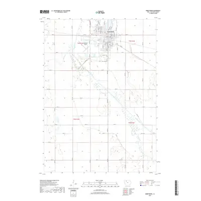
2018 Map of Emmetsburg
USGS Topo · Published 2018About this map
Emmetsburg sits at a critical bend in the Des Moines River, serving as a centralized hub for the agricultural landscape of Palo Alto County. This 2018 survey details a sophisticated grid of streets including Main St, Grand Ave, and Lake Shore Dr, reflecting the town's role as a regional anchor. The surrounding terrain is defined by complex drainage patterns, including the winding course of Silver Cr and the unique formation of Bushy Bayou. To the south of the main settlement, the Emmetsburg Municipal Airport and the neighboring Evergreen Cem and Saint Johns Cem provide important landmarks for local genealogy and regional transit. The presence of the Old Channel indicates the shifting nature of the river over time, highlighting the environmental history of the Iowa plains.
Find a feature on this map
72 named features on this map. Tap any name to fly to it.
Don’t see what you’re looking for? This feature index may not catch every label — zoom into the map to look around manually.
Map Details
Editions of this 2018 Emmetsburg Map
This is the sole edition of this map. No revisions or reprints were ever made.
Other maps of this area

1954 · Fairmont
USGS Topo · 1:250,000

1954 · Fort Dodge
USGS Topo · 1:250,000

1957 · Fort Dodge
USGS Topo · 1:250,000

1958 · Fort Dodge
USGS Topo · 1:250,000

1958 · Fairmont
USGS Topo · 1:250,000

1971 · Rush Lake East
USGS Topo · 1:24,000

1972 · Graettinger West
USGS Topo · 1:24,000

1972 · Ayrshire
USGS Topo · 1:24,000

1980 · Depew
USGS Topo · 1:24,000
1980 · Mallard
USGS Topo · 1:24,000