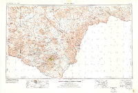
1959 Map of Emory Peak
USGS Topo · Published 1978About this map
Big Bend National Park dominates this high-contrast survey of the Trans-Pecos frontier, capturing the remote desert landscape along the Rio Grande as it stood in the late 1950s. The topographic detail highlights the dramatic ascent from the riverbed through Santa Elena Canyon up to the high-altitude Chisos Mountains, anchored by the summit of Emory Peak 7825. Sparse settlements like Terlingua, Lajitas, and Castolon mark the few human outposts in a terrain defined by ancient geological structures such as The Solitario and the Santiago Mountains. Remote outposts including the Pershington Gap Ranger Station and Boquillas (Rio Grande Village) suggest a landscape transition from working ranchland and mining districts toward a managed wilderness, while named springs like Dull Springs and Cottonwood Spring pinpoint vital water sources in an otherwise arid expanse of Brewster County.
Find a feature on this map
139 named features on this map. Tap any name to fly to it.
Don’t see what you’re looking for? This feature index may not catch every label — zoom into the map to look around manually.
Map Details
Editions of this 1959 Emory Peak Map
3 editions found

Other maps of this area

1895 · Marfa
USGS Topo · 1:125,000

1895 · Alpine
USGS Topo · 1:125,000

1896 · Polvo
USGS Topo · 1:125,000

1896 · Shafter
USGS Topo · 1:125,000

1903 · Chisos Mountains
USGS Topo · 1:125,000

1903 · Terlingua
USGS Topo · 1:125,000

1904 · Terlingua
USGS Topo · 1:125,000

1905 · Chisos Mountains
USGS Topo · 1:125,000

1917 · Agua Fria
USGS Topo · 1:62,500

1917 · Tascotal Mesa
USGS Topo · 1:62,500