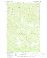
1965 Map of Empey Mountain
USGS Topo · Published 1980About this map
Huckleberry Mountain and Empey Mountain define the high country of Stevens County, where the landscape transitions into the broad Camas Valley. This mid-century topography reveals an area dominated by the hydrology of the Chamokane Creek system, including its Middle Fork and South Fork. The southern edge of the map is defined by the Spokane Indian Reservation Boundary, illustrating the intersection of public and tribal lands. Resource extraction is evident through scattered markers for a Mine, a Prospect, and multiple Gravel Pits along the creek beds. These features, along with several Jeep Trails cutting through Sorenson Canyon and near Cooney Mountain, show a working landscape of timber and mineral interest in the years following the 1965 field check.
Find a feature on this map
20 named features on this map. Tap any name to fly to it.
Don’t see what you’re looking for? This feature index may not catch every label — zoom into the map to look around manually.
Map Details
Editions of this 1965 Empey Mountain Map
Other maps of this area

1927 · Chewelah
USGS Topo · 1:125,000

1930 · Chewelah
USGS Topo · 1:125,000

1944 · Wellpinit
USGS Topo · 1:62,500

1948 · Hunters
USGS Topo · 1:62,500

1948 · Turtle Lake
USGS Topo · 1:62,500

1950 · Turtle Lake
USGS Topo · 1:62,500

1950 · Hunters
USGS Topo · 1:62,500

1953 · Wellpinit
USGS Topo · 1:62,500

1953 · Ritzville
USGS Topo · 1:250,000

1954 · Okanogan
USGS Topo · 1:250,000