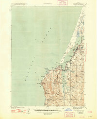
1944 Map of Empire
USGS Topo · Published 1948About this map
Coos Bay and the Pacific coastline define this wartime-era survey of the Oregon coast, showing a landscape dominated by timber, maritime activity, and family ranching. The settlement of Empire serves as a primary hub alongside Charleston and Barview, while the rugged shoreline is protected by Cape Arago State Park and Coos Head State Park. Inland, the map reveals a network of coastal sloughs and creeks, including South Slough and Joe Ney Slough, which provided vital access for early commerce.
Find a feature on this map
64 named features on this map. Tap any name to fly to it.
Don’t see what you’re looking for? This feature index may not catch every label — zoom into the map to look around manually.
Map Details
Editions of this 1944 Empire Map
4 editions found
Other maps of this area

1896 · Coos Bay
USGS Topo · 1:125,000

1898 · Coos Bay
USGS Topo · 1:125,000

1900 · Coos Bay
USGS Topo · 1:125,000

1923 · Reedsport
USGS Topo · 1:62,500

1942 · Reedsport
USGS Topo · 1:62,500

1942 · Empire
USGS Topo · 1:62,500

1942 · Coquille
USGS Topo · 1:62,500

1942 · Coos Bay
USGS Topo · 1:62,500

1943 · Bandon
USGS Topo · 1:62,500

1944 · Empire
USGS Topo · 1:62,500