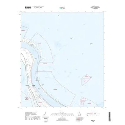
2018 Map of Empire
USGS Topo · Published 2018About this map
The Mississippi River winds through the heart of Plaquemines Parish in this 2018 survey, defining a narrow strip of habitable land bounded by the Pointe A La Hache Relief Outlet and a network of wetlands. This landscape is a patchwork of bayous and bays, where small settlements like Empire and Tropical Bend sit along the levee system. For those researching local families, the presence of Nairn Cem, Cannon Cem, and the Point Pleasant Cem offers valuable reference points for historic community centers near Nairn and Point Pleasant. Beyond the river banks, the terrain dissolves into a complex aquatic environment featuring the Ballandock Canal, Spanish Pass, and the broad reaches of California Bay. The map captures the delicate balance between the industrial and transport infrastructure of the river and the encroaching waters of the Gulf of Mexico, visible near Bosco Island and Quarantine Bay.
Find a feature on this map
59 named features on this map. Tap any name to fly to it.
Don’t see what you’re looking for? This feature index may not catch every label — zoom into the map to look around manually.
Map Details
Editions of this 2018 Empire Map
This is the sole edition of this map. No revisions or reprints were ever made.
Other maps of this area

1892 · Quarantine
USGS Topo · 1:62,500

1893 · La Fortuna
USGS Topo · 1:62,500

1893 · Forts
USGS Topo · 1:62,500

1893 · Dime
USGS Topo · 1:62,500

1935 · Port Sulphur
USGS Topo · 1:31,680

1935 · Bastian Bay
USGS Topo · 1:31,680

1935 · Tropical Bend
USGS Topo · 1:31,680

1941 · Black Bay
USGS Topo · 1:62,500

1941 · Empire
USGS Topo · 1:62,500
1944 · Black Bay
USGS Topo · 1:62,500