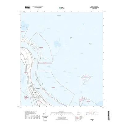
2020 Map of Empire
USGS Topo · Published 2020About this map
The Mississippi River carves through the heart of Plaquemines Parish on this 2020 map, flanked by a complex system of levees and relief structures. Along the river's western bank, the settlements of Empire, Tropical Bend, and Nairn represent the resilient human footprint on this delta landscape. These communities are defined by their proximity to the water, linked by roads like Levee Rd and Hwy 11. The mapping of several small burial grounds, including Nairn Cem, Cannon Cem, and Mackey Cem, provides essential points of reference for genealogical research in this shifting coastal environment.
Find a feature on this map
63 named features on this map. Tap any name to fly to it.
Don’t see what you’re looking for? This feature index may not catch every label — zoom into the map to look around manually.
Map Details
Editions of this 2020 Empire Map
This is the sole edition of this map. No revisions or reprints were ever made.
Other maps of this area

1892 · Quarantine
USGS Topo · 1:62,500

1893 · La Fortuna
USGS Topo · 1:62,500

1893 · Forts
USGS Topo · 1:62,500

1893 · Dime
USGS Topo · 1:62,500

1935 · Port Sulphur
USGS Topo · 1:31,680

1935 · Bastian Bay
USGS Topo · 1:31,680

1935 · Tropical Bend
USGS Topo · 1:31,680

1941 · Black Bay
USGS Topo · 1:62,500

1941 · Empire
USGS Topo · 1:62,500
1944 · Black Bay
USGS Topo · 1:62,500