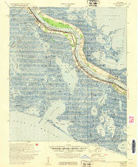
1953 Map of Empire
USGS Topo · Published 1953About this map
Mississippi River levees and the industrial footprint of the mid-century petroleum industry define this landscape in Plaquemines Parish. The settlements of Empire, Buras, and Port Sulphur line the narrow corridor of dry land between the river and the encroaching waters of the Gulf of Mexico. Along this stretch, the map records numerous family and community landmarks, including the Roxy Jane Cem, Nairn Cem, and Mt Zion Ch, which sit just behind the protection of the riverbank. The economic drivers of the era are visible in the Potash Oil Field and Bastian Bay Oil Field, reflecting a time when oil and sulfur extraction were rapidly reshaping the wetlands. Pumping stations and relief outlets like the Relief Outlet demonstrate the constant engineering required to maintain habitable ground in this river-delta environment.
Find a feature on this map
88 named features on this map. Tap any name to fly to it.
Don’t see what you’re looking for? This feature index may not catch every label — zoom into the map to look around manually.
Map Details
Editions of this 1953 Empire Map
This is the sole edition of this map. No revisions or reprints were ever made.
Other maps of this area

1891 · Pointe a La Hache
USGS Topo · 1:62,500

1892 · Quarantine
USGS Topo · 1:62,500

1892 · Pointe a La Hache
USGS Topo · 1:62,500

1893 · La Fortuna
USGS Topo · 1:62,500

1893 · Forts
USGS Topo · 1:62,500

1893 · Fort Livingston
USGS Topo · 1:62,500

1893 · Dime
USGS Topo · 1:62,500

1893 · West Delta
USGS Topo · 1:62,500

1935 · Port Sulphur
USGS Topo · 1:31,680

1935 · Bastian Bay
USGS Topo · 1:31,680