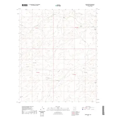
2023 Map of Encino Draw
USGS Topo · Published 2023About this map
Encino Draw and a network of ephemeral watercourses define this high-desert landscape in Chaves County. The terrain is deeply incised by a series of drainages, including Horse Canyon and Bear Canyon, which move water toward broader lowlands like Bell Flat during seasonal rains. This 2023 survey illustrates the modern ranching infrastructure of the region, where roads such as Cauhape Ranch Rd and Russel Gap Rd provide access to isolated water sources like Hall Tank. These human-made features are critical for livestock management in an environment where natural permanent water is scarce. The map also traces the long paths of Long Canyon Draw and Fourmile Draw, showing how physical geography dictates the placement of county roads and ranch tracks in this corner of New Mexico.
Find a feature on this map
22 named features on this map. Tap any name to fly to it.
Don’t see what you’re looking for? This feature index may not catch every label — zoom into the map to look around manually.
Map Details
Editions of this 2023 Encino Draw Map
This is the sole edition of this map. No revisions or reprints were ever made.
Other maps of this area

1954 · Carlsbad
USGS Topo · 1:250,000

1958 · Carlsbad
USGS Topo · 1:250,000

1960 · Teel Ranch
USGS Topo · 1:62,500

1962 · Dunken
USGS Topo · 1:62,500

1965 · Lewis Peak NE
USGS Topo · 1:24,000

1965 · Bullis Spring Ranch
USGS Topo · 1:24,000

1978 · Strychnine Draw
USGS Topo · 1:24,000

1978 · Encino Draw
USGS Topo · 1:24,000

1978 · Artesia
USGS Topo · 1:100,000
1978 · Holt Tank
USGS Topo · 1:24,000