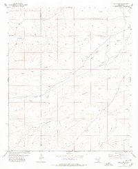
1978 Map of Holt Tank
USGS Topo · Published 1979About this map
Holt and Bullis sit within a high desert landscape marked by a complex system of drainage channels and ranching infrastructure during the late 1970s. The border between Chaves Co and Eddy Co cuts through the northern section of the sheet, where the terrain is dominated by various seasonal washes including Fourmile Draw and Walnut Draw. The map reveals the vital importance of water management in this arid region of New Mexico, evidenced by numerous man-made features such as Holt Tank, New Tank, and various unnamed tanks and wells. Industry is represented by a Gravel Pit near New Tank, while a long-distance Pipeline traverses the landscape from the southwest toward the northeast. The intricate network of named draws, such as Catclaw Draw and Gardner Draw, highlights how the natural geography dictated the placement of early ranching outposts and infrastructure.
Find a feature on this map
18 named features on this map. Tap any name to fly to it.
Don’t see what you’re looking for? This feature index may not catch every label — zoom into the map to look around manually.
Map Details
Editions of this 1978 Holt Tank Map
This is the sole edition of this map. No revisions or reprints were ever made.
Other maps of this area

1954 · Carlsbad
USGS Topo · 1:250,000

1955 · Hope
USGS Topo · 1:24,000

1956 · Hope
USGS Topo · 1:24,000

1956 · Antelope Sink
USGS Topo · 1:24,000

1957 · Box Canyon Ranch
USGS Topo · 1:24,000

1958 · Carlsbad
USGS Topo · 1:250,000

1960 · Teel Ranch
USGS Topo · 1:62,500

1978 · Strychnine Draw
USGS Topo · 1:24,000

1978 · Encino Draw
USGS Topo · 1:24,000

1978 · Artesia
USGS Topo · 1:100,000