
1973 Map of Enders
USGS Topo · Published 1977About this map
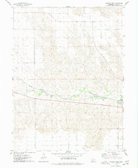
Enders Reservoir dominates the landscape of Chase County in the mid-1970s, its waters covering a portion of the Frenchman Creek valley. The small settlement of Enders sits at the northern edge of the reservoir, serving as a focal point for local transportation and recreation. The Burlington Northern railroad cuts through the terrain, passing just east of the village and the Enders Dam Airport. This era of development is marked by an emphasis on public leisure, evidenced by the Church Grove Recreation Area and a Golf Course situated along the shoreline. Further east, the Enders Dam itself and nearby Gaging Stations reveal the managed nature of the regional watershed. Scattered throughout the northern plains, numerous points labeled Well indicate the importance of groundwater for agriculture and local residency in this high plains environment.
Find a feature on this map
15 named features on this map. Tap any name to fly to it.
Don’t see what you’re looking for? This feature index may not catch every label — zoom into the map to look around manually.
Map Details
Editions of this 1973 Enders Map
This is the sole edition of this map. No revisions or reprints were ever made.
Other maps of this area

1954 · McCook
USGS Topo · 1:250,000

1957 · McCook
USGS Topo · 1:250,000

1958 · McCook
USGS Topo · 1:250,000

1973 · Champion
USGS Topo · 1:24,000

1973 · Champion SW
USGS Topo · 1:24,000

1973 · Imperial
USGS Topo · 1:24,000

1973 · Ough
USGS Topo · 1:24,000

1973 · Wauneta SW
USGS Topo · 1:24,000

1973 · Imperial Municipal Airport
USGS Topo · 1:24,000
1974 · Wauneta West
USGS Topo · 1:24,000